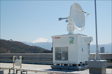


X-band Multiparameter Radar for Meteorology
On UY-GCOE program, X-band Multiparameter Radar for Meteorology(X-MP Radar) was installed in Kofu Campus of University of Yamanashi and started to observe precipitating phenomena from April, 2009. In the Kofu Basin, no radar for meteorology had been installed before April 2009. So, we have not been able to obtain rainfall information in detail. We expect that the radar gives the detail information of precipitation occurred in the Kofu Basin and around mountainous regions.
Observation of X-MP Radar
Radar for meteorology transmits a radio wave to a precipitating region from the antenna. When the transmitting radio wave arrived at the rainfall region, it is scattered by rain drops. Then the radar receives the scattering radio wave at the antenna. We can get the position of the rainfall region using the time of going and returning of the radio wave. Furthermore, we can obtain the rainfall intensity using the received power of the scattering radio wave. X-band radar uses the radio wave with relatively shorter micro wave length (about 3.2 cm). Transmitting the radio wave with short wave length and receiving the scattering radio wave as the antenna rotating, the radar obtains high resolution and wide-ranging rainfall information.
X-MP Radar transmits two radio waves, Horizontal polarimetric wave and Vertical polarimetric wave. Then, the radar receives the scattering radio waves, respectively. Rain drops have various sizes and shapes. From the observation using the polarimetric radio waves, we can estimate the sizes, shapes and irregularity of rain drops distributed on a precipitating cloud. Then we expect the high accuracy estimation of precipitating amount from the observing parameters derived by the observation using the polarimetric radio waves. Our new radar can transmit Dual-Polarimetric radio waves.
Our new radar can observe the movement of rain drops in a precipitating cloud using Doppler effect. The example of Doppler effect is the phenomenon that you listen the changing wail of an ambulance siren when the ambulance comes close to or leaves from you. The moving velocity of rain drops (an ambulance) along the radio wave (the sound wave of a siren) is estimated by the change of frequency of the radio wave scattered by moving rain drops (the sound wave transmitted from the moving ambulance). The velocity calculated by the change of frequency of the wave transmitted from a moving object is called 'Doppler Velocity.' Using Doppler velocity, we can estimate the airflow in a precipitating cloud because rain drops move with airflow. Doppler velocity data is useful for the detections of downburst, tornado and so on.
Scientific and technological achievement using X-MP Radar
1) Formation Process of Heavy rainfall caused a flood
The Kofu Basin and surrounding mountainous regions are one of the regions where many flood damages are caused by heavy rainfall.
On the mountainous region, heavy rainfall often causes a landslide, a debris flow and so on. Moreover, heavy rainfall on the mountainous region often causes the increase of water level of river of mountains origin.
On the other hand, sudden heavy rainfall in a short time often occurs on the Kofu Basin.
The heavy rainfall often caused urban flood damage (eg. the flood by sudden increase of water level of small river among urban communities).
It is necessary for the mitigation of damage caused by heavy rainfall and the planning of prevention investigating the formation process and condition of heavy rainfall.
Furthermore, it is also necessary for the prediction of damage to give the quantitative, detail and highly accurate information of heavy rainfall.
On UY-GCOE program, we investigate the structure and formation process of heavy rainfall which occurs on the Kofu Basin and surrounding mountainous regions using the X-MP Radar.
Then, we develop the method of the quantitative estimation of rainfall (eg. rainfall amount, rainfall area, and the period of rainfall duration) and consider the possibility of highly accurate prediction of heavy rainfall.
2) Detections of the severe wind
Severe winds (eg. downburst, tornado and so on) often occur with a developing cumulonimbus cloud. The severe winds occur in very local region and have very short life time.
So, it is very difficult to detect and predict the severe winds. Using the radar data with the high temporal and high spatial resolutions, we analyze the formation process of severe winds caused with a developing cumulonimbus cloud.
Then, we apply the detection of severe winds using the radar.
3) Application for prevention and decrease of damage
The data of precipitation observed the X-MP Radar is applied to the prediction of an urban flood using numerical flood model developed by UY.
Then we develop the system of warning information of a landslide, a debris flow and an urban flood. We develop the prevention model from flood damage on the Kofu Basin and surrounding mountainous regions.